Santiago from above: join me on a trek: ! [ENG | ESP]
One of the things I like most about Santiago de Chile is also one of the things that makes me somewhat sad. Located between several mountain ranges, the most notable being the Andes mountain range that separates the country from its Argentine neighbors, Santiago not only has several mountains surrounding the city on the outskirts, but also more than two dozen "Cerros Islas" (Island Hills) located within the city that can be climbed. In fact, one of the favorite things to do for Santiago residents—especially on weekends—is to climb a hill and contemplate the city from above.
Una de las cosas que más me gusta de Santiago de Chile es también una de las cosas que me provoca cierta pena. Ubicada entre varios sistemas montañosos, siendo el más destacado la cordillera de los andes que separa al país de sus vecinos argentinos, Santiago tiene no sólo varias montañas alrededor de la ciudad, en las afueras, sino que posee más de dos docenas de Cerros Islas que están ubicados dentro de la ciudad y que pueden escalarse. De hecho, uno de los panoramas favoritos de los santiaguinos - sobre todo los fines de semana - es subir un cerro y contemplar la ciudad desde lo alto.
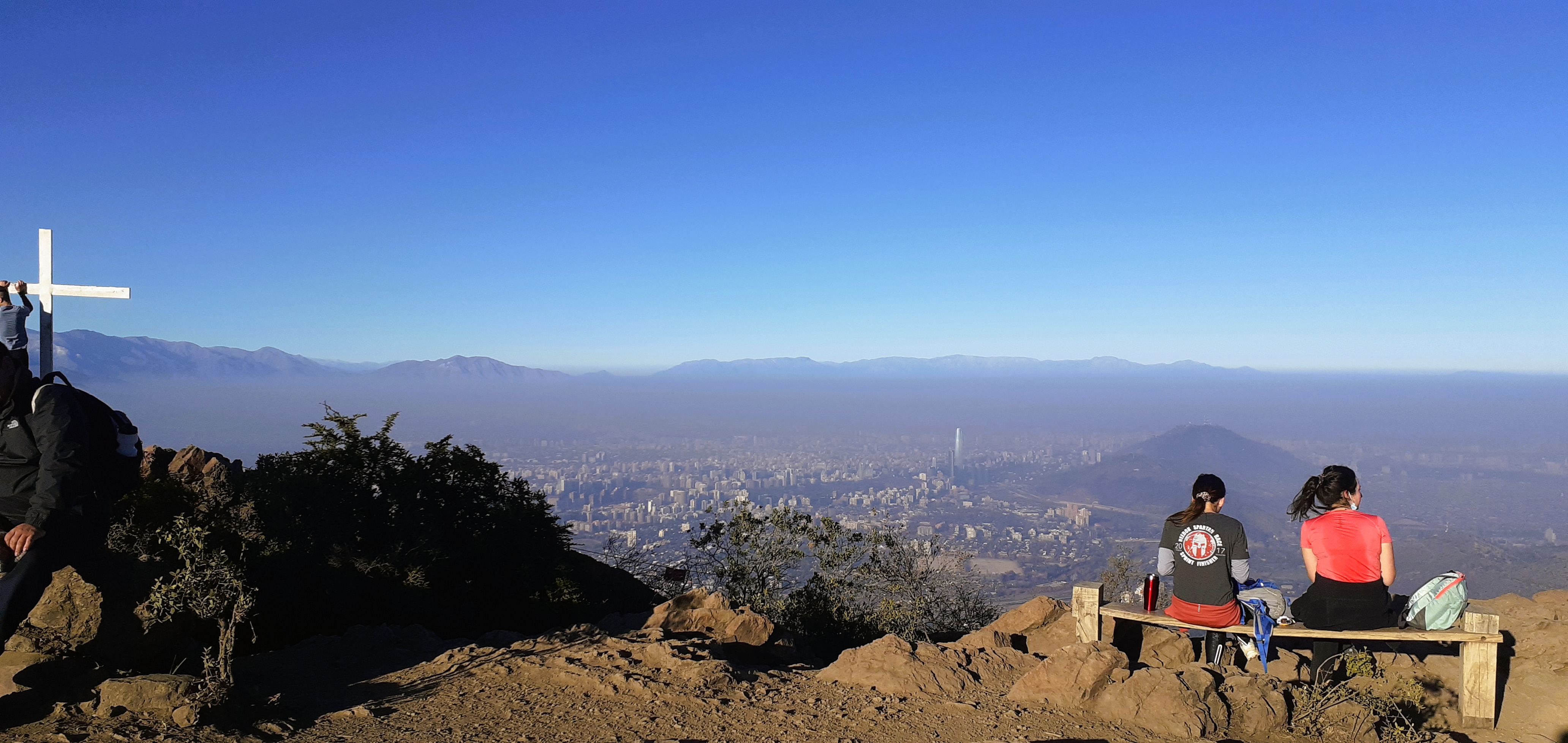
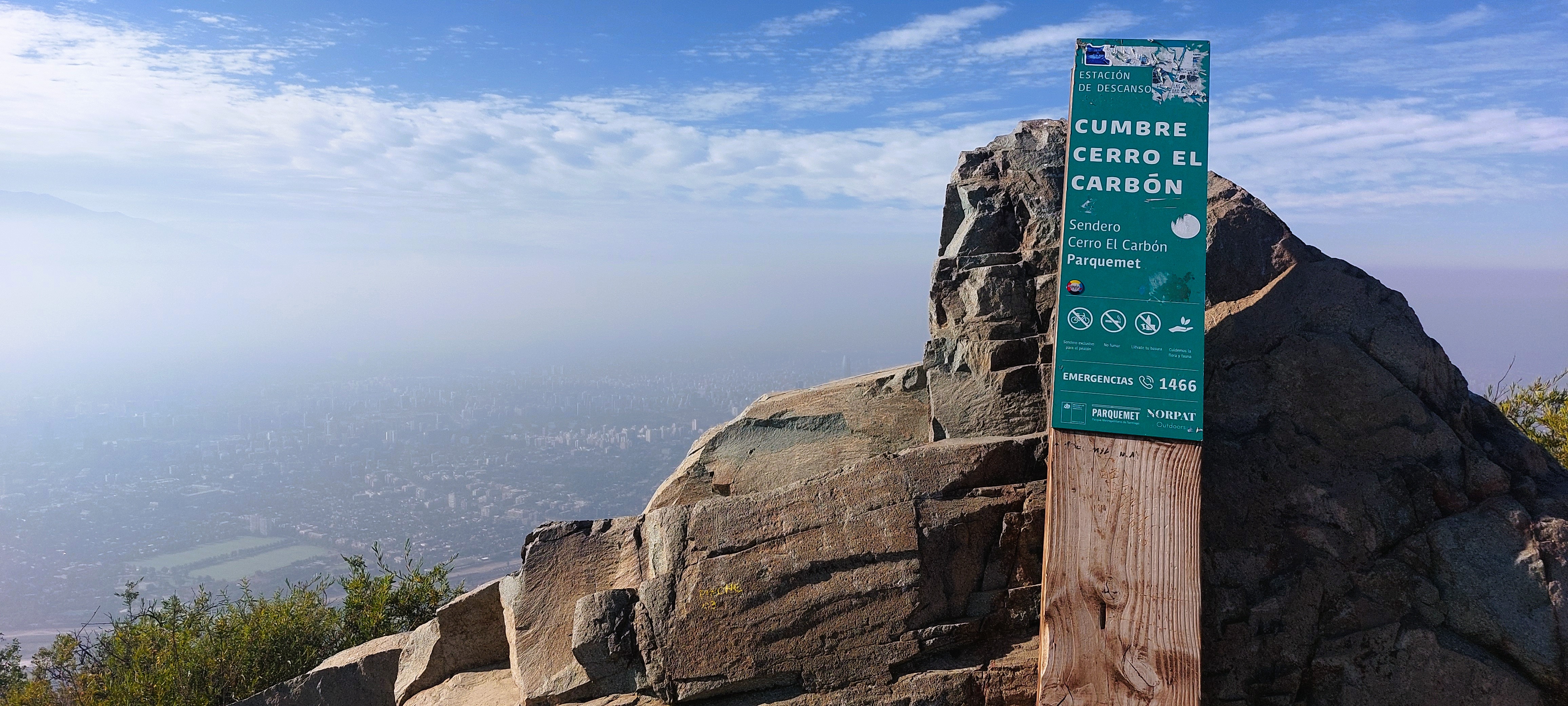
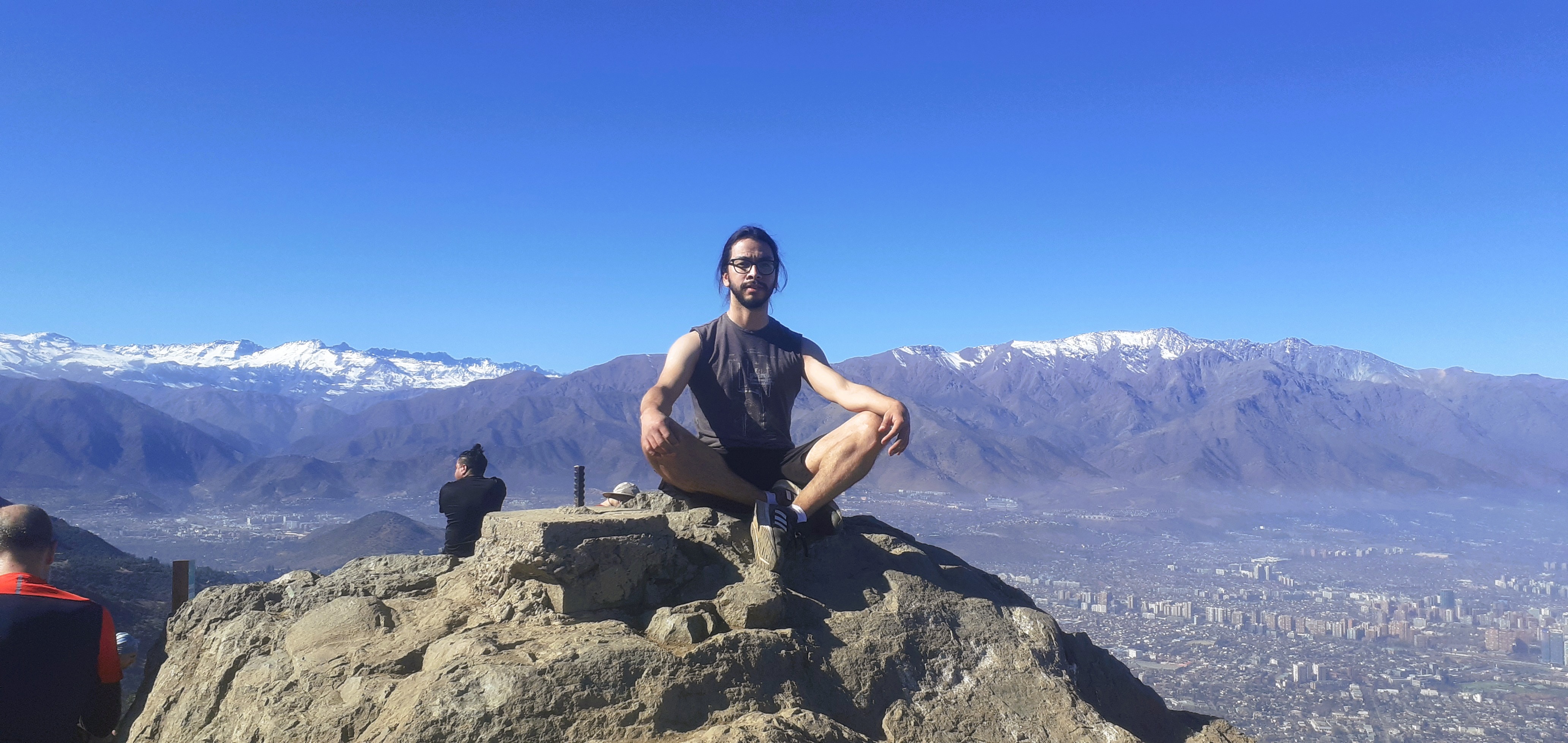
Hills like Santa Lucía, San Cristóbal, Cerro Blanco, Cerro Calán, all of them are part of the nature mixed with the urban, but three very famous ones, because they are located next to each other, are Cerro Manquehue, Manquehuito and Cerro el Carbón. Climbing all three in the same day is known as “Doing the triple crown” and although it's demanding, especially if you're not used to trekking, it was precisely the first contact I had with these three peaks. The cover photo, where you can see a white cross on the left side, is the summit of Manquehuito. And if you look at the center of the photo you will be able to see - in the distance - a building towering above all the others. Although it looks small due to the height and distance from the site, that building is the Costanera Center, the tallest building in South America (and the second tallest in Latin America) at 300 meters high, see how small it looks in the photo? Well, that's because the top of the Manquehuito hill is at 1,319 meters above sea level. A little higher, at 1,365 meters, stands Cerro el Carbon, the only one of the triple crown that I have revisited - and on several occasions, because the terrain is firmer and because the access to climb is the only one of the three that is fairly close to a bus stop. A plan I've made a few times is to climb the hill early in the morning, have breakfast at the summit and stay there to read for a couple of hours before descending and stopping at some viewpoints. I consider it a trail of little difficulty, despite the slope at the beginning and the rocks at the summit, which can be completed in less than an hour at a good pace, or in an hour and a half if you are not very used to doing this kind of things.
Cerros como el Santa Lucía, el San Cristóbal, Cerro Blanco, el Cerro Calán, todos ellos forman parte de la naturaleza que se mezcla con lo urbano, pero tres muy famosos, por estar ubicados uno al lado del otro, son el Cerro Manquehue, el Manquehuito y el Cerro el Carbón. Subir los tres en un mismo día se conoce como "Hacer la triple corona" y aunque es exigente, sobre todo si no estás acostumbrado a hacer treking, fue precisamente el primer contacto que tuve con estas tres cumbres. La foto de portada, en donde se ve una cruz blanca al lado izquierdo es la cumbre del Manquehuito. Y si se fijan en el centro de la foto van a poder observar - en la distancia - un edificio que se erige sobre todos los demás. Aunque se ve pequeño debido a la altura y la distancia desde el lugar, ese edificio es el Costanera Center, el edificio más alto de América del Sur (y el segundo más alto de latinoamérica) con 300 metros de altura, ¿ven cuán pequeño se ve en la foto? Bueno, eso es porque la cumbre del cerro Manquehuito está a 1.319 msnm. Un poco más alto, con 1.365 msnm se erige el Cerro el Carbón, el único de la triple corona que he vuelto a visitar - y en varias ocasiones, porque el terreno es más firme y porque el acceso para subir es el único de los tres que está bastante cerca de un paradero de buses. Un plan que he hecho algunas veces es subir el cerro temprano en la mañana, desayunar en la cumbre y quedarme allí a leer un par de horas antes de descender y parar en algunos miradores. Considero que es un sendero de poca dificultad, a pesar del desnivel del principio y las rocas de la cumbre, que se puede completar en menos de una hora a buen ritmo, o en una hora y media si no estás muy acostumbrado a hacer este tipo de cosas.
I mentioned that I liked this possibility of climbing a lot of mountains near the city, but that it also made me sad. This is because, being located on a plateau nestled in the middle of these hills, Santiago is a city where there isn't much wind, which causes the smog to concentrate over the city. Hence, the view from the heights isn't as clear as those I've seen in other cities in Chile or other countries. Except after it rains. Although it doesn't rain much in the Chilean capital, when it rains, the polluted air settles, allowing the sky to appear bluer and the view clearer.
Mencioné que me gustaba esta posibilidad de subir un montón de montañas cerca de la ciudad, pero que también me causaba pena y es porque al estar ubicado en una meseta encajonada en medio de estas colinas, Santiago es una ciudad en la que no corre mucho viento y eso hace que el smog se concentre sobre la ciudad. De allí que la vista desde las alturas no sea tan nítida como las que he podido ver en otras ciudades de Chile o en otros países. Salvo, después de la lluvia. A pesar de que no llueve mucho en la capital chilena, cuando hay precipitaciones, el aire contaminado se asienta y eso permite que el cielo se vea más azul y la vista más despejada.
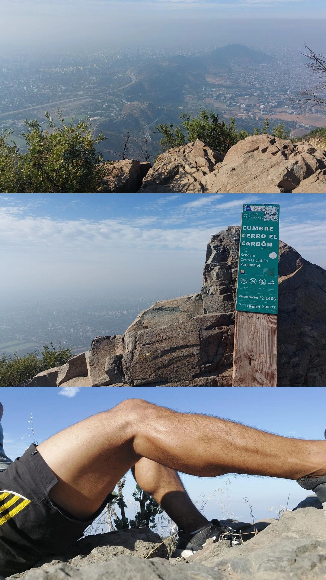
Now, what you see in the photos is not only smog, you can also see some fog because it was very early in the morning, so in hours closer to noon the sky can be seen a little clearer. It's best to climb the hill during the spring or fall when temperatures are cooler. If you go in the summer, climb it early so that the most intense hours of sunshine do not find you climbing or at the top, because it's not a place where there's a lot of shade for shelter. And of course take something to eat, plenty of water and sunscreen. And if in addition to El Carbon, you also want to climb the other two hills that are nearby, it's imperative that you take appropriate footwear. In El Carbon the terrain is quite firm and I think that with regular sneakers you can manage well, but in Manquehuito the soil is very loose and in order to have grip you need good shoes and - if you can and you like it - you can also use trekking poles. And if you like trails that can take you to a river or waterfalls, then I recommend the Parque Aguas de Ramón or the Quebrada de Macul. In the first one you have to pay an entrance fee of about 3 USD, but the second one is free, and in both cases you will find a path without much slope that after an hour, or a little less, will take you to a river in which you will be able to swim if you wish. And all this without the need to leave the city or travel to the countryside, because both places can be reached by public transport and are within the limits of the Chilean capital. I share with you some pictures taken from the summit of Cerro El Carbon:
Ahora bien, lo que observan en las fotos no es solamente smog, también se ve algo de niebla porque era muy temprano en la mañana, así que en horas más cercanas del mediodía el cielo se puede ver un poco más despejado. Lo más recomendable es subir el cerro durante la primavera o el otoño cuando las temperaturas están más frescas. Si van en el verano súbanlo temprano para que las horas más intensas de sol no los encuentren subiendo o en la cima, porque no es un lugar en el que haya mucha sombra para resguardarse. Y por supuesto lleven algo de comer, mucha agua y protector solar. Y si además de El Carbón, quieren subir también los otros dos cerros que están cerca, es imperativo que se lleven el calzado adecuado. En el Carbón el terreno es bastante firme y creo que con unas zapatillas de deporte regulares se pueden manejar bien, pero en el Manquehuito la tierra es muy suelta y para poder tener agarre necesitan un buen calzado y - si pueden y les gusta - también pueden ocupar bastones de treking. Y si les gustan más los senderos que los pueden llevar a un río o a caídas de agua, entonces les recomiendo el Parque Aguas de Ramón o la Quebrada de Macul. En el primero hay que pagar una entrada de unos 3 USD aproximadamente, pero el segundo es gratuito, y en ambos casos se van a encontrar con un sendero sin mucho desnivel que después de una hora, o poco menos, los llevará hasta un río en el cual van a poder bañarse si así lo desean. Y todo esto sin necesidad de salir de la ciudad o de viajar al campo, porque a ambos lugares se puede llegar en transporte público y están dentro de los límites de la capital chilena. Les comparto algunas fotografías tomadas desde la cumbre del cerro el Carbón:

So, if you're visiting Santiago de Chile and have time to explore the natural surroundings, you'll find plenty of hiking opportunities where you can admire the Chilean capital from above, in some cases from 2,000 or 3,000 meters. How many of you enjoy hiking and admiring places from above? What view do you remember that impressed you? I'll read you in the comments.
Así que si vienen de visita a Santiago de Chile y les da tiempo de darse una vuelta por la naturaleza que rodea la ciudad, van a encontrar muchas alternativas para hacer senderismo y poder contemplar la capital chilena desde las alturas, en algunos casos desde los dos mil o tres mil metros, ¿a cuántos de ustedes les gusta hacer senderismo? ¿y contemplar los lugares desde las alturas? ¿qué vista recuerdan que los haya impresionado? Los leo en los comentarios.
Text and Pictures: | Texto e imágenes:
Other posts that may interest you | Otros posts que pueden interesarte:
 |
|---|
You can check out this post and your own profile on the map. Be part of the Worldmappin Community and join our Discord Channel to get in touch with other travelers, ask questions or just be updated on our latest features.
Thank you so much for you support!
Hey @cristiancaicedo you are welcome.
Thanks for using @worldmappin 😘
The view you can see is very beautiful. You did it very well.
Thank you for your kind words.
Hiya, @lauramica here, just swinging by to let you know that this post made it into our Honorable Mentions in Travel Digest #2525.
Your post has been manually curated by the @worldmappin team. If you like what we're doing, please drop by to check out all the rest of today's great posts and consider supporting other authors like yourself and us so we can keep the project going!
Become part of our travel community:
The natural scenery is truly amazing, you managed to capture the beauty from a height that looks truly amazing ❤️
Nature's amazing!
You are absolutely right, ❤️
hello @cristiancaicedo
The view from the top is always amazing but the journey up is not always easy.
greetings
It's true but it worths it, no doubt!
The view you shared is very very nice
Thank you