My Actifit Report Card: July 28 2024/#8.Refresher holiday,Hiraodai Trekking Details. /#8.リフレッシュ休暇・平尾台トレッキング詳細/[ENG/JPN]
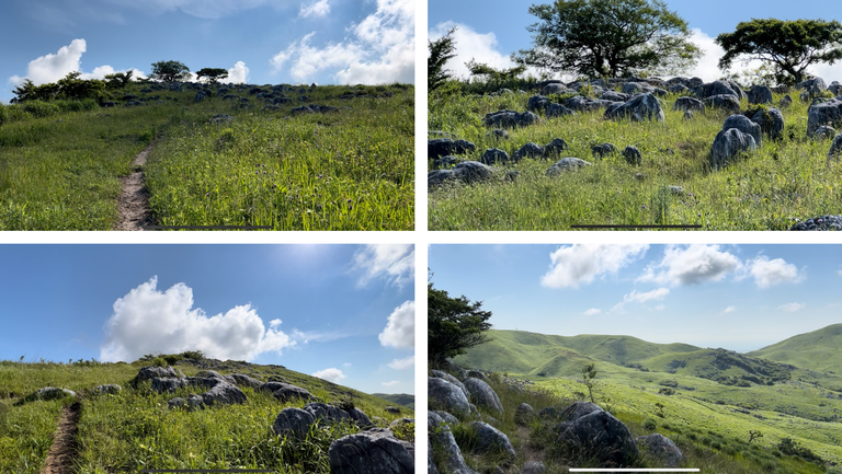
The article in Japanese is in the second half.★日本語の記事は後半に。
The Hiraodai trek was the axis event of our refresher vacation.
I was most looking forward to it and was blessed with excellent conditions and took a lot of great pictures.
Here are some of the previous fabrics I posted in conjunction with the Refreshing Vacation camp.
My Actifit Report Card: June 15 2024| #3.Refresher holiday,Hiraodai Karst Plateau Trekking and Camping 2nd night /#3.リフレッシュ休暇・平尾台カルスト台地トレッキングとキャンプ2日目の夜/[ENG/JPN]
I went trekking with my iPhone and GoPro.
I had actually thought about bringing a compact digital camera as well, but I agonized over it until the last minute and decided to prioritize reducing my luggage and did not bring a digital camera.
But there was a lot to see with just the iPhone and GoPro, especially if I used the GoPro to shoot video and cut out still images from it.
In addition, I still have data from using a mountain climbing app to search for climbing routes and decide on this course, so I'll put all of that together as well to make a proper summary.
I hear that many different mountaineering apps have been released all over the world.
Many seem to be very useful, with many climbers uploading their achievements and recognised model routes registered.
I use an app called YAMAP, which probably has the most users in Japan.
Users can upload and share course time achievements, and if there are any abnormalities on the trail along the way, the situation can be filmed and alerted.
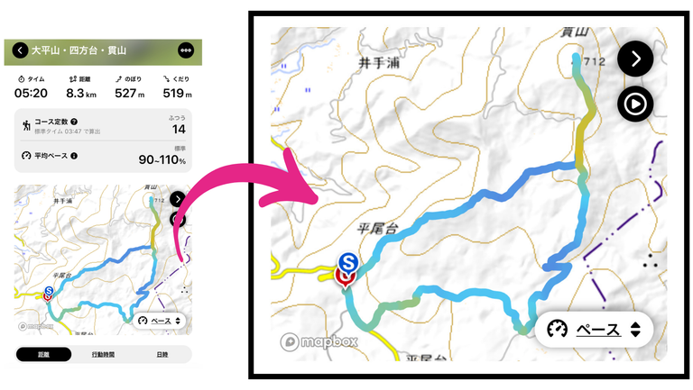
As this was my first time in the mountain area, I downloaded a model route from the app beforehand.
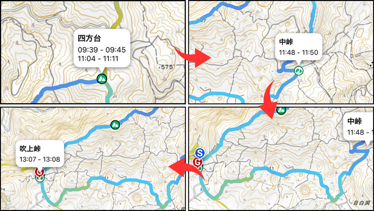
The 'S' and 'G' on the map are the parking areas closest to the trailhead at the start (and finish) point.
This shows the results, so you can see my climbing result: distance = 8.3 km, time = 5:20.
This is 90-110% of the average pace, they say.
I love recording this kind of data and I love seeing the numbers like this later.
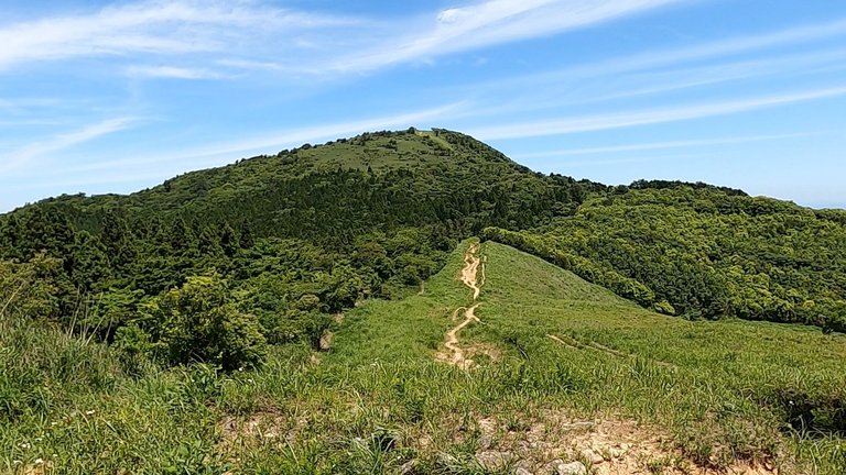
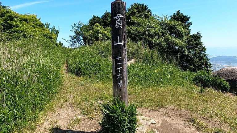
The mountain in the picture is Nukisan, the highest point on this route.
The mountain range itself is not that high this time, and this summit is also about 720m above sea level.
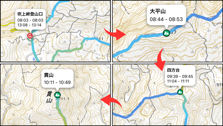
I took a screenshot of the map in the app.
Starting from the top left of the four maps, I went from top right to bottom right to bottom left.
Mt Nukiyama is bottom left and from the record of my results I can see that I arrived at 10:11.
I had lunch at the summit and left the summit at 10:49.
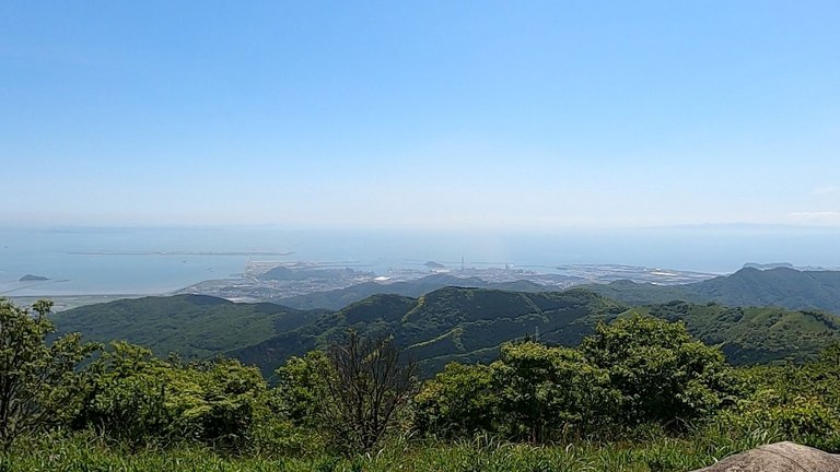
This is a picture of the summit of Nukisan (Nukisan).
Although the summit was partly overgrown with trees, the view was very good and we could see far into the distance and as far as the sea.
If you had started climbing the mountain early in the morning, the 10:00hrs is exactly lunch time.
A few other climbers were also eating lunch at the summit.
I was also hungry because I had eaten breakfast at around 5:00 am, so I was very hungry and I devoured the two rice balls I had brought with me in a single sitting.
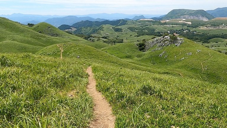
I descended from Nukisan and returned to Shiho-dai (四方台) at the junction, from where I walked towards Naka-Touge (中峠).
It was during this descent route that I realised that my shoes were in very bad condition and checked the rest stops along the way.
The rest stop was in the middle of the route from the beginning, but I planned to pass by it.
Whether you use it or not, it's important to include a place on the route where you can take a break.
I was able to sit on a covered bench, give first aid to my shoe sores and walk all the way to the start/finish point.
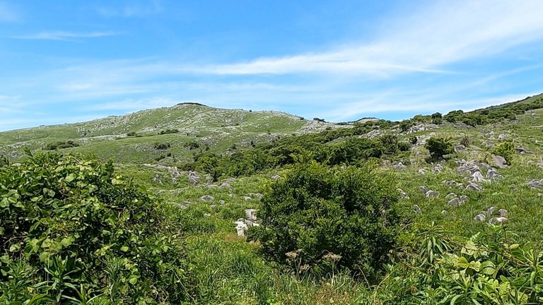
As you can see from the photos, Hiraodai has a very good vantage point and you can see what is going on in the distance.
However, when the view is too good, it is surprisingly difficult to grasp the distance (LOL).
You may feel like you are close, but when you actually walk, you realise that you are much further away than you thought.
It is very reassuring to be able to track the course time on the app at times like this.
When you have an injured leg and the time to the rest stop is unclear, it can be very discouraging.
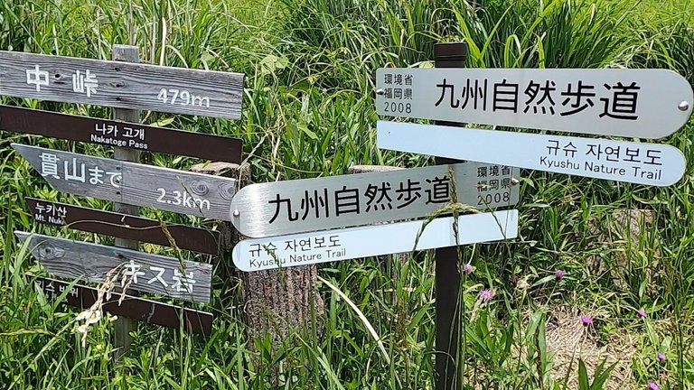
There were many signs down the middle pass and out to the paved road.
This is because this is the trailhead if you are coming up from the direction of the rest area I was aiming for.
Looking up at Hiraodai again, I was impressed by the wonderful sight under the blue sky.
While I was impressed, my shoe sores were sore and I thought, let's treat them quickly.
It is really important to have an emergency kit with you.
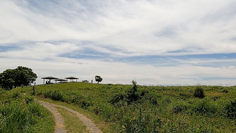
I treated my wounds well at the rest area and started walking towards the goal.
At this rest stop, there were groups of people who had come just to eat their lunch without climbing the mountain, and others who looked like they were just stopping off for a bit on their drive or touring trip.
There was a brief period of cloudiness, but soon blue skies again and I was able to walk under much better weather.
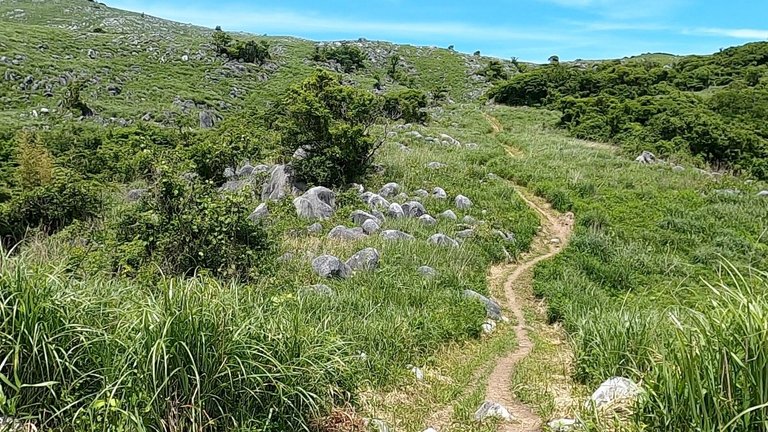
The return walk was a level walk along the foot of the Hiraodai, the white limestone of the karst plateau was really beautiful and I was able to enjoy the views all the way.
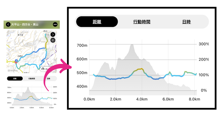
The final graph of results looks like this.
The line graph shows the distance walked and the mountains in the background are the height differences.
The first low peak, Ooherayama, and the highest peak on the way up, Nukisan, show a large difference in height, indicating that the first part of the climb was quite steep.
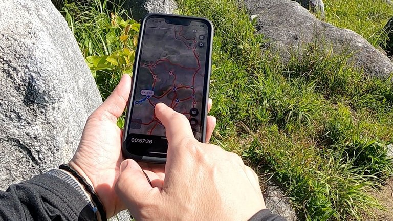
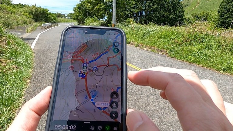
As you can see in the photo, I was just checking the map on my hiking app, thinking that I was almost there before the goal parking area.
I had to walk along the public roadway to get to this location, and I had to check the map many times to get to the car park as quickly as possible.
You have to be careful on an open general carriageway like this, because cars are speeding up the road.
It is pure fun to look back at the photos and data in this way.
I want to continue to take a lot of documentary footage when I go on trips or climb mountains.
I also looked back on my luggage when I got home, so I'll write about that in the next article as well.
I really had a lot to reflect on regarding my belongings.
See you next time.

■diary with a few words
I think it is summer fatigue, but I feel very tired.
I'm really getting weak against the summer heat, but to begin with, the Ministry of the Environment warns that the current summer heat in Japan is "unprecedented" and among the warnings is that "conventional heat measures will not work".
The best thing to do is not to overdo it.


Japanese★ここから日本語でお送りいたします。
平尾台トレッキングは、リフレッシュ休暇の軸になるイベントでした。
最も楽しみにしていたし、最高のコンディションに恵まれて最高の写真がたくさん撮れました。
リフレッシュ休暇のキャンプと合わせて投稿した以前の生地はこちらです。
My Actifit Report Card: June 15 2024| #3.Refresher holiday,Hiraodai Karst Plateau Trekking and Camping 2nd night /#3.リフレッシュ休暇・平尾台カルスト台地トレッキングとキャンプ2日目の夜/[ENG/JPN]
私はiPhoneとGoProを持ってトレッキングに行きました。
本当はコンパクトデジカメも持って行こうかと考えていましたが、直前まで悩んで、荷物を減らす方を優先し、デジカメは持っていきませんでした。
でも、iPhoneとGoProだけでもかなりの数になり、特にGoProでは動画を撮影し、その中から静止画を切り出すようにしたらたくさんの見所がありました。
さらに登山アプリを使って登山のルートを検索して今回のコースを決めたデータも残っているので、それらも全て合わせてきちんとまとめておこうと思います。

登山アプリは世界中に色々なものがリリースされているらしいですね。
多くの登山家が実績をアップロードされていたり、認められている模範ルートが登録されていたり、非常に便利に使えるものが多いようです。
私は日本でおそらく最もユーザーの多いYAMAPというアプリを使っています。
ユーザーがコースタイム実績をアップロードして共有したり、途中の登山道に異常があった場合は状況を撮影して注意喚起をすることも可能です。
初めて行く山域なので、私は事前に模範ルートをアプリからダウンロードして行きました。
地図の中の「S」「G」がスタート(およびゴール)地点の登山口最寄り駐車場です。
これは実績が表示されているので、私の登山結果:距離=8.3km、タイム=5:20が見えます。
これは平均的なペースの90〜110%だそうです。
私はこういうデータを記録するのが大好きで、後からこうして数字を見るのも大好きです。

写真の山は「貫山(Nukisan)」という今回のルートで最も高い地点です。
今回は山域そのものがそれほど標高は高くなくて、この山頂も標高720mほどです。
アプリの地図のスクリーンショットを撮ってみました。
4つの地図の左上からスタートし、右上→右下→左下と私は進んで行きました。
貫山は左下で、実績の記録から、到着したのは10:11だと分かります。
山頂でランチを食べて、10:49に山頂を出発しました。

これは「貫山(Nukisan)山頂」の写真です。
山頂は、一部、木が生い茂っている場所もありましたが、とても見晴らしが良く、遠くの方まで見ることができて、海まで見渡すことができました。
早朝に登山を開始していた場合、10:00台はちょうどランチタイムです。
他の登山者も、数人が山頂でお弁当を食べていました。
私も朝ごはんを食べたのが5時頃でしたから、お腹が空いていて、持参したおにぎり2個をぺろりと食べてしまいました。

貫山(Nukisan)から下山し、分岐点の四方台(Shiho-dai)に戻り、そこから中峠(Naka-Touge)に向かって歩きました。
私はこの下山ルートの途中で、自分の靴擦れの状態が非常に悪いことを察知し、途中の休憩場所をチェックしました。
休憩場所はルートの途中に最初から入っていましたが、通り過ぎる予定でした。
利用するかしないかは別として、休憩できる場所をルートに組み込むのは重要ですね。
私は屋根のあるベンチに座ることができて、靴擦れの応急処置をして、スタート/ゴール地点まで歩き切ることができました。
写真を見ていただいている通り、平尾台は非常に見晴らしが良く、遠くの状況が分かります。
しかし、見晴らしが良すぎると意外と距離感が把握できません(lol)
近いような気がしても、実際に歩いてみると思ったよりかなり遠いことがわかります。
こういう時にアプリでコースタイムを把握できることはとても心強いです。
足を怪我している状態で、休憩場所までの時間が不明確だととても心細くなります。

中峠をくだり、舗装された道路まで出たところにはたくさんの標識がありました。
私が目指している休憩場所方面から登ってきた場合、ここが登山口になるためです。
改めて平尾台を見上げると、青空の下に素晴らしい光景が広がっていて感動しました。
感動しつつも靴擦れが痛くて、早く治療しよう、と思いました。
エマージェンシーキットを持っておくのは本当に重要ですね。

私は休憩場所でしっかり傷口を処置して、ゴールに向かって歩き出しました。
この休憩場所では、山登りをしなくてもお弁当を食べるためだけにきているグループもいましたし、ドライブやツーリングの途中でちょっと立ち寄った風の人もいました。
一時的に雲が多くなることもありましたが、すぐにまた青空が広がって、私はずっと良い天気の下を歩くことができました。
帰り道は平尾台の麓を水平に歩くことになりましたが、カルスト台地の白い石灰岩が本当に美しく、私はずっと景色を堪能できました。

最終的な実績のグラフはこのようになりました。
折れ線グラフが歩いた距離で、背景のようになっている山の形が高低差です。
最初の低いピークの大平山(Ooherayama)と、途中の最も高いピークの貫山(Nukisan)が大きく高低差に現れていて、最初がかなり急登だったことがわかります。
写真のようにゴールの駐車場手前では、もう後少しなんだけどな、と考えながら登山アプリの地図を確認していたところです。
この場所は、どうしても一般車道を歩いて進まなければならず、早く駐車場に辿り着きたくて何度も地図を確認していました。
こんな風に空いている一般車道は車がスピードを出して走っているので、注意が必要ですね。
こうして写真やデータを振り返るのは純粋に楽しいですね。
これからも旅に出たり山に登ったりした時は、色々と記録映像を撮りたいと思います。
帰宅してから荷物の振り返りもしたので、それについても次回以降に記事にしようと思っています。
持ち物については反省することが本当に多かったです。
それでは次回。

■ひとこと日記
夏バテなんだと思いますが、倦怠感が酷いです。
本当に夏の暑さに対してに弱くなってきましたが、そもそも現在の日本の夏の暑さは「過去に類を見ない」と環境省から警告が出ていて、その中で「従来の暑さ対策は通用しない」ことも警告されています。
無理しないことが一番ですね。
Google Translate & DeepL, thank you as always.
I am glad that you read it :-)
今日も読んでくださってありがとうございます😊
This report was published via Actifit app (Android | iOS). Check out the original version here on actifit.io



Congrats on providing Proof of Activity via your Actifit report!
You have been rewarded 64.145 AFIT tokens for your effort in reaching 13480 activity, as well as your user rank and report quality!
You also received a 25.29% upvote via @actifit account. 25.00% of this upvote value is a result of an exchange transaction you performed for 200 AFIT tokens !
AFIT rewards and upvotes are based on your:
To improve your user rank, delegate more, pile up more AFIT and AFITX tokens, and post more.
To improve your post score, get to the max activity count, work on improving your post content, improve your user rank, engage with the community to get more upvotes and quality comments.
Chat with us on discord | Visit our website
Follow us on Twitter | Join us on Telegram
Download on playstore | Download on app store
Knowledge base:

FAQs | Whitepaper
How to signup | Maximize your rewards
Complete Actifit Tutorial
Support our efforts below by voting for:
You haven’t run into bear’s or boars? I went hitchhiking in Yamanashi twice to get to an eco village and then I heard some stories about bears nearby and I have been too scared to go again 😅
Thank you for your comments, I am very sorry for the inconvenience!
Actually, it turns out that there are already no bears in the trekking area I am writing about.
In the Kyushu region of Japan, wild bears are extinct.
Bears are really scary and I have an overwhelming lack of knowledge on how to deal with bears, so I try to stay away when there is information about bears being present😅.
However, boars are present in the area where we trekked and camped this time. The campsite manager told us to be careful because of the possibility of boars, deer and monkeys appearing. Wild animals are scary.
We need to be especially careful with our food. Wild animals are attracted by the smell of food, so we humans are responsible for managing our food.
I think a bell and some spray is enough not to worry but I hope I have someone to join me, especially in the forest!
Black bears usually don’t attack people but sometimes they are curious and accidentally hurt humans or our sudden behavior startles them. Either way I’m still scared of them.
If you come to Tokyo let me know. I want to have more meetups in Japan!
旅をいっぱい楽しんでください!^_^